Scan and Understand
REscan is where spatial capture meets neural intelligence to transform how the world is digitized and understood through AI-Driven Spatial Insights. Our end-to-end AI pipeline -from scanning to visualization on mobile phones- delivers actionable intelligence for teams in real time.
Using our lightweight scanner helmet, large indoor and outdoor environments are rapidly captured from a human perspective. Advanced analysis systems reconstruct these spaces in full-color 3D, interpreting every element and converting them into searchable, data-rich digital assets. Real-time streaming to an intuitive mobile app delivers the environments and insights into the palm of your hand.
REscan turns every space into an AI-enhanced 3D digital twin, enabling remote access, optimized workflows, predictive analytics, and a deeper machine understanding of the physical world.
Get the Viewer Application at:


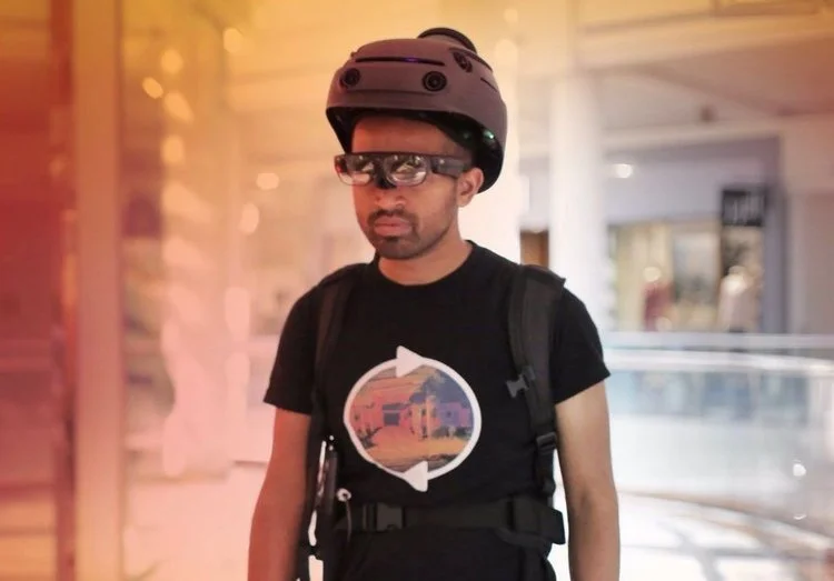
Capture From a Human Perspective
With our proprietary Gen 6 Scanner, we’ve condensed full self-driving car technology into a wearable, hands-free device that captures large indoor and outdoor environments with unprecedented speed from a human point of view.
A single operator can scan up to 250,000 sq.ft. per hour- moving through complex multi-floor environments, navigating stairs, opening doors, maneuvering tight retail layouts, and threading through narrow industrial spaces.
Unlike traditional tripod-based scanning, which for large spaces can take days or weeks to complete, REscan delivers high-quality, continuous scanning in a single pass, even in huge active environments.
Capture When Busy or Empty
We capture indoor and outdoor locations as fast as you can walk through them- no need to close or clear areas.We just show up and go.
In our AI pipeline we filter noise, and reconstruct clean, accurate models. We also remove people and private information to ensure secure, compliant data - ready for immediate use. You focus on the mission; we fortify your data securit.
Explore AI-Enhanced Spaces From a Human POV
Captured data flows into REscan’s AI pipeline, where environments are reconstructed in full-color 3D. Our systems interpret objects and architectural elements, transforming raw point clouds into searchable, context-rich digital assets. Backed by our patented deep learning and computer vision technology (19+ granted patents), each digital twin is accurate, contextually aware, searchable, and fully interactive.
The result is an AI-enhanced 3D digital twin - a living environment that enables remote access, workflow optimization, predictive analytics, and asset management. With our mobile viewer, insights are literally at your fingertips: navigate spaces from a human perspective or switch to dollhouse mode for a complete overview. Instantly locate and inventory assets, streamline operations, and support predictive decision-making - all within a secure, interactive platform.
Accuracy and Robustness
ReScan delivers exceptionally accurate, large-scale 3D scans. Our technology uses multi-sensor fusion and advanced AI to eliminate mapping errors and generate state-of-the-art models for decision support, robotics, and AI applications.
Unlike traditional SLAM, which struggles with lighting changes, moving objects or even just repetitive environments, REscan maintains an “unbreakable” map that adapts and reliably recognizes previously visited places, creating robust, drift-free maps- even in large, dynamic, or challenging environments.
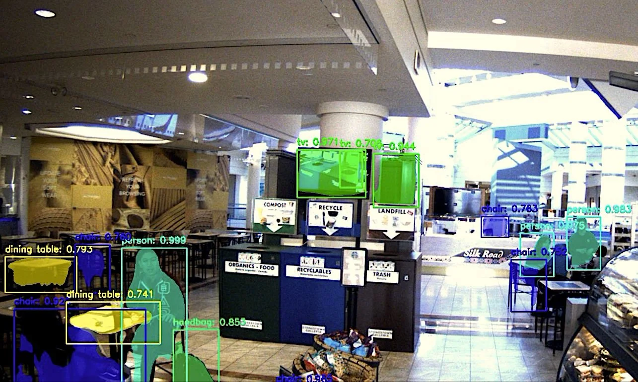
Distributed AI-Accelerated 3D Annotation
Data labeling is one of the most challenging parts of building AI. REscan’s mobile, AI-assisted annotation platform enables rapid semantic labeling across distributed teams, helping create industry- and customer-specific enhanced instance segmentation datasets.
Our platform leverages the precise geometry of the 3D world to automatically generate pixel-perfect, fully labeled training datasets for state-of-the-art object detection models. This human-in-the-loop AI can accelerate labeling by up to 1,000×, producing flawless transfer learning datasets by reverse-casting 3D segmentations back into the original 2D scan images for verification. We turn one capture into a vast treasure trove of AI training data.
Domain experts and on-site teams can refine AI results directly on mobile devices, creating a continuous feedback loop that improves learning and boosts accuracy over time.
See It In Action Right Now
Experience a 3,700,000 sq.ft. 3D scan of downtown Redwood City -including the History Museum and Fox Theater interiors -captured in under two hours and viewable on Android or iPhone. See how REscan turns captured spaces into intelligent digital environments.
REscan: Reality, upgraded.
Get the viewer application at:


REscan is proud to collaborate with leading industry and government partners


App features: AI Driven Spatial Intelligence
Our platform enables professionals to digitally visit, analyze, and manage properties anywhere - with the power of AI built in.
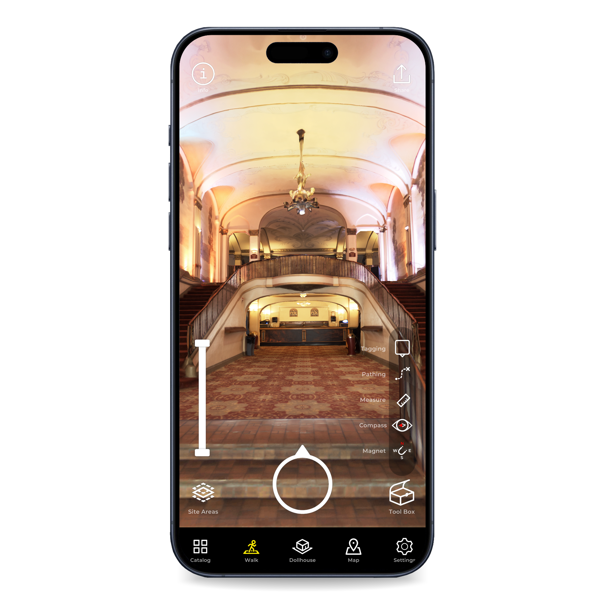
Explore
Move through spaces at speed with adaptive real-time streaming

Catalog
Instantly search and find spaces.

Dollhouse View
View the entirety of a scanned site in birds eye view

Top Down View
Classic overhead view with smarts.

Information
Access site management details and documents.

Share
Send 3D views via SMS, Email, Slack, and more.

Settings
Personalize your experience

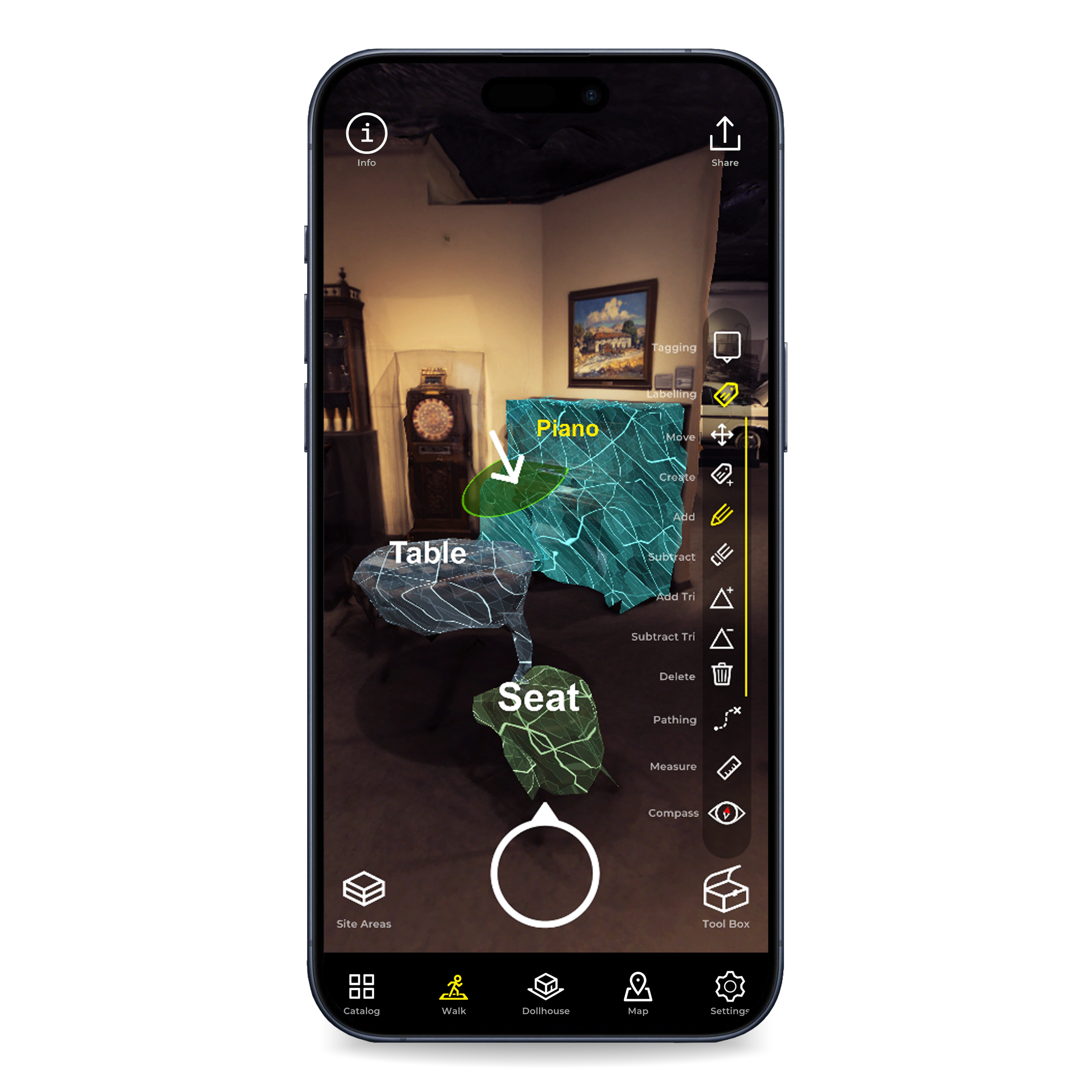
Tagging
Mark objects and attach notes, files, or maintenance info.

Pathing
Automatically find optimal routes through complex sites.

Map
Pinpoint and visualize geolocated site boundaries on real maps.

Measure
Capture precise real-world dimensions anywhere.

Compass
Real-world directions

AR
View spaces with Augmented Reality

Site Areas
Toggle visibility of rooms, floors, or functional zones.

Labeling [Beta]
Rapidly build AI training datasets for searchable 3D Intelligence.